scarabaeus
 2008.01.01 2008.01.01
|
|
0 0
268
|
Érdemes átmenni a Google Earthbe, a linkből kiszedni a koordinátákat (-27.967929,153.419266), és beilleszteni a "Fly to" mezőjébe. Ezután bekapcsolni a bal oldalon a "Geographic Web" réteget és a jelenleg a "Gallery"-n belül található "Google Earth Community" réteget. Sok információt, fényképet kaphatunk az adott pontokhoz. Ehhez is:
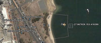
Ilyen infók vannak ott pl.:
1. link
"nah the swimming area already has a type of fence to stop boats and sharks and things.
mostly kids just swim to the float to do jumps off it.
when i went there it was covered in bird poo:-)"
2. link
"I live just up the road and pass it all the time. It is a pontoon. The square thing around this "man" is a shark exclusion device to ensure that all the kids are safe.
If you are interested, this is part of the Broadwater, on the Gold Coast Australia. The suburb is Southport."
|
Előzmény: hNeo (264)
|
|